
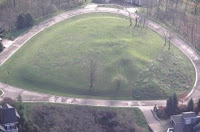
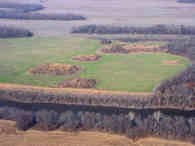
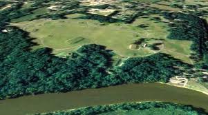
The Alligator Effigy Mound is a nationally recognized historic site in Granville, Ohio, United States. A prehistoricearthwork, the mound was likely built between AD 800 and 1200 by people of the Fort Ancient culture.[2] The mound was likely a ceremonial site, as it was not used for burials.
Alligator Mound is one of two known effigy mounds located in the present-day state of Ohio, the other one being Serpent Mound in Adams County, Ohio.[2][3] It has been listed on the National Register of Historic Places since 1971.[1]Effigy mounds were built more often by ancient indigenous peoples located in the areas of the present-day states of Illinois, Iowa, and Wisconsin, and many have survived there.[2][3]
Early American settlers thought the mound represented an alligator. Since alligators are not found in Ohio, some researchers believe the figure represents a local animal, such as an opossum, salamander, or panther.
In 1999 Brad Lepper and Tod A. Frolking conducted an archaeological investigation of the mound. By radiometric dating of a piece of charcoal recovered from the base of the mound, they estimate its construction to have been 1,000 years BP (about 950 CE).[2] Lepper suggests that the Alligator Mound is an effigy of an underwater panther, a powerful figure in Native American myth. He thinks that early European settlers misinterpreted what Native Americans told them about the effigy. They were told that it was a fierce creature that lived in the water and ate people, which they assumed to be an alligator.[4] The mound is located on privately owned land at the end of Bryn Du Drive, within the village limits of Granville.
For over a thousand years, Southwestern Indiana was home to many Native Americans. Today, Angel Mounds State Historic Site is nationally recognized as one of the best preserved prehistoric Native American sites in the United States. From 1100 to 1450 A. D., a town on this site was home to people of the Middle Mississippian culture, who engaged in hunting and farming on the rich bottom lands of the Ohio River. Several thousand people lived in this town protected by a stockade made of wattle and daub. Because Angel Mounds was a chiefdom (the home of the chief) it was the regional center of a large community that grew outward from it for many miles.
This settlement was the largest known town of its time in Indiana, but the Mississippian people eventually deserted it. No one today knows why. Fortunately, preservation and archaeological efforts at Angel Mounds State Historic Site offer a glimpse into this highly developed culture of the distant past. For 60 years, this living museum has told the story of one pre-contact Native American culture on the Ohio River.
Characteristic of their culture, the Mississippian people at Angel built mounds in their town. In chiefdoms like Angel, the high-status families lived and were sometimes buried on top of some of the mounds. Priests and chiefs carried out ceremonies and rituals on the large temple mounds that dominated the town. Some of the mounds at Angel have been excavated by archaeologists, and they contain evidence of being many things: site of the chief’s residence, religious and burial locations, garbage dumps, even natural elevations.
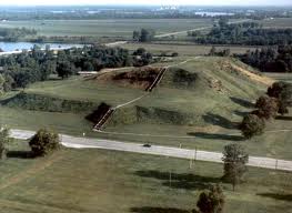
Cahokia Mounds State Historic Site is located on the site of an ancient Native American city (c. 600–1400 CE) situated directly across the Mississippi River from modern St. Louis, Missouri. This historic park lies in southern Illinous between East St. Louis and Collinsville. The park covers 2,200 acres (890 ha), or about 3.5 square miles, and contains about 80 mounds, but the ancient city was actually much larger. In its heyday, Cahokia covered about 6 square miles and included about 120 man-made earthen mounds in a wide range of sizes, shapes, and functions.
Cahokia was the largest and most influential urban settlement in the Mississippian culture which developed advanced societies across much of what is now the Southeastern United States, beginning more than 500 years before European contact. Cahokia’s population at its peak in the 1200s was among the largest cities in the world, and its ancient population would not be surpassed by any city in the United States until the late 18th century. Today, Cahokia Mounds is considered the largest and most complex archaeological site north of the great Pre-Columbian cities in Mexico.
The Castalian Springs Mound Site (40SU14), also known as Bledsoe’s Lick Mound and Cheskiki Mound, is a Mississippian culture archaeological site located near the small unincorporated community of Castalian Springs inSumner County, Tennessee. The site was first excavated in the 1890s and again as recently as the 2005 to 2011 archaeological field school led by Dr. Kevin E. Smith. A number of important finds have been associated with the site, most particularly several examples of Mississippian stone statuary and the Castalian Springs shell gorget held by the National Museum of the American Indian.
The Castalian Springs site is the largest of four Mississippian mound centers on the eastern edge of the Nashville basin, located on a flood terrace of a tributary creek of the Cumberland River. It was occupied from 1100 to 1450 CE. The palisaded village and surrounding habitation area was approximately 40 acres (0.16 km2) in size and consisted of a dozen platform mounds, a burial mound, plaza and a number of dwellings and civic structures. The site was first noted in the early 1820s by Ralph E.W. Earl, who did extensive digging at the site. He described a low earthen embankment with raised earthen towers enclosing 16 acres (0.065 km2), the remnants of what is now known to have been a wooden palisade. Earl also described the principal mound ( Mound 1) inside the enclosure as being a compound structure consisting of a rectangular platform 600 feet (180 m) long by 200 feet (61 m) wide and 13 feet (4.0 m) to 15 feet (4.6 m) in height and aligned in an east-west direction. On the western end of the platform was a conical shaped mound with a flattened top, approximately 18 feet (5.5 m) to 20 feet (6.1 m) in height. On the southern side of the mound was a plaza, which was bordered on its eastern edge by a 120 feet (37 m) in diameter 8 feet (2.4 m) tall burial mound (Mound 2) and on its western edge by another large platform mound (Mound 3). Outside of the palisade to southwest on the banks of Lick Creek was a stone mound (Mound 4) 60 feet (18 m) in diameter and 5.5 feet (1.7 m), similar examples of which have been found at the Beasley Mounds and Sellars Indian Mound sites. Over the years since Earls first description Euro-Americans have plowed the area for agricultural purposes and consequently the main platform mound and a few raised impressions are all that are still visible of the embankment and the 12 platform mounds once contained within it. Scattered throughout the area archaeologists have also found stone box graves, mortuary caves and other features thought to be associated with the Castalian Springs site. The karst terrain of the area produced numerous small caves, one of which is located a few hundred yards west of the Castalian Springs site. Known locally as the “Cave of the Skulls” (40SU126), this small cave was explored by Myer at sometime during one of his three excavation of the site.

Etowah Indian Mounds is a 54-acre (220,000 m2) archaeological site in Bartow County, Georgia south of Cartersville, in the United States. Built and occupied in three phases, from 1000–1550 CE, the prehistoric site is located on the north shore of the Etowah River. Etowah Indian Mounds Historic Site is a designated National Historic Landmark, managed by the Georgia Department of Natural Resources. It is the most intact Mississippian culture site in the Southeastern United States.
In the 19th century, European-American settlers mistakenly believed that the mounds had been built by the Cherokee, who then occupied the region; however, the Iroquoian-speaking tribe did not reach this part of Georgia until the late 18th century and could not have built the mounds.
Late 20th-century studies showed the mounds were built and occupied by prehistoric indigenous peoples of the South Appalachian Mississippian culture (a regional variation of the Mississippian culture) of eastern North America. They were ancestors of the historic Muskogean language-speaking Muscogee (Creek) people who later emerged in the area. Etowah is a Muskogee word derived from italwa meaning “town”. The federally recognized Muscogee (Creek) and Poarch Band of Creek Indians consider Etalwa to be their most important ancestral town. From 1000–1550 CE, Etowah was occupied by a series of cycling chiefdoms over the course of five and a half centuries.
The Kincaid Mounds Illinois Historic Site consists of 105 acres at the heart of the Kincaid Mounds Archaeological Site. Portions of the Archaeological Site extend to private property north and east of the Historic Site. The State property has been designated a National Historic Landmark and is on the National Register of Historic Places of the United States. The Kincaid Mounds Support Organization is a local non-profit corporation that manages the site under contract with the Illinois Historic Preservation Agency. At present, public access is limited to an observation/interpretation platform adjacent to Kincaid Mounds Road (see Location icon on this page). The goals for the Historic Site include preservation of the archaeological resource, facilitation of research, and interpretation of the site to the public.
Between 1000 and 700 years ago, the first people to practice large scale agriculture in the southern Illinois area established Kincaid Mounds as the seat of their Chiefdom. These Native Americans were of the Mississippian culture and occupied Kincaid from approximately 1050 AD to 1400 AD. They were ruled by a chief who inherited his position and probably claimed power from the sun. Corn or maize farmers in the lowlands along the Ohio River from Hamletsburg upstream to Brookport downstream supported the leaders with grain and constructed the mounds we see today. They also constructed the buildings and the protective wall or palisade that encircled the principal mounds, but which we now know only from the archaeological record.
The mounds are raised platforms on which the Chief and other elite leaders of this society lived or ruled from, and on which thatch-roofed homes, ceremonial buildings, and temples were constructed. The mounds were built in stages over a 350 year period by stacking basket loads of selected soil and clay material one on top of another. They stand today much as they appeared 700 years ago.
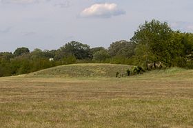
Moundville Archaeological Site, also known as the Moundville Archaeological Park, is a Mississippian culture site on the Black Warrior River in Hale County, near the city of Tuscaloosa, Alabama. Extensive archaeological investigation has shown that the site was the political and ceremonial center of a regionally organized Mississippian culture chiefdom polity between the 11th and 16th centuries. The archaeological park portion of the site is administered by the University of Alabama Museums and encompasses 185 acres (75 ha), consisting of 29 platform mounds around a rectangular plaza. The site was declared a National Historic Landmark in 1964 and was added to the National Register of Historic Places in 1966.
Moundville is the second-largest site of the classic Middle Mississippian era, after Cahokia in Illinois. The culture was expressed in villages and chiefdoms throughout the central Mississippi River Valley, the lower Ohio River Valley, and most of the Mid-South area, including Kentucky, Tennessee, Alabama and Mississippi as the core of the classic Mississippian culture area.[4] The park contains a museum and an archaeological laboratory.
The site was occupied by Native Americans of the Mississippian culture from around 1000 AD to 1450 AD. Around 1150 AD it began its rise from a local to a regional center. At its height, the community took the form of a roughly 300-acre (121 ha) residential and political area protected on three sides by a bastioned wooden palisade wall, with the remaining side protected by the river bluff. The largest platform mounds are located on the northern edge of the plaza and become increasingly smaller going either clockwise or counter clockwise around the plaza to the south. Scholars theorize that the highest-ranking clans occupied the large northern mounds, with the smaller mounds’ supporting buildings used for residences, mortuary, and other purposes. Of the two largest mounds in the group, Mound A occupies a central position in the great plaza, and Mound B lies just to the north, a steep, 58 feet (18 m) tall pyramidal mound with two access ramps; it rises to a height of 58 feet. Along with both mounds, archaeologists have also found evidence of borrow pits, other public buildings, and a dozen small houses constructed of pole and thatch.
Archaeologists have interpreted this community plan as a sociogram, an architectural depiction of a social order based on ranked clans. According to this model, the Moundville community was segmented into a variety of different clan precincts, the ranked position of which was represented in the size and arrangement of paired earthen mounds around the central plaza. By 1300, the site was being used more as a religious and political center than as a residential town. This signaled the beginning of a decline, and by 1500 most of the area was abandoned.
Ocmulgee National Monument preserves traces of over ten millennia of Southeastern Native American culture, including major earthworks built more than 1,000 years ago by the South Appalachian Mississippian culture (a regional variation of the Mississippian culture.) These include the Great Temple and other ceremonial mounds, a burial mound, and defensive trenches. They represented highly skilled engineering techniques and soil knowledge, and the organization of many laborers. The site has evidence of “17,000 years of continuous human habitation.” The 702-acre (2.84 km2) park is located on the east bank of the Ocmulgee River. Present-day Macon, Georgia developed around the site after the United States built Fort Benjamin Hawkins nearby in 1806.
Varying cultures of prehistoric indigenous peoples settled on what is called the Macon Plateau at the Fall Line, where the rolling hills of the Piedmont met the Atlantic Coastal Plain. The monument designation includes the Lamar Mounds and Village Site, located downriver about three miles (5 km) from Macon. The monument park was designated for federal protection by the National Park Service (NPS) in 1934 and listed on the National Register of Historic Places in 1966. In 1997, the NPS designated the monument a Traditional Cultural Property, the first so recognized east of the Mississippi River.
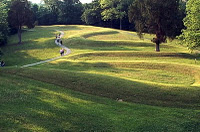
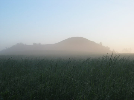
The Great Serpent Mound is a 1,348-foot (411 m)-long, three-foot-high prehistoric effigy mound located on a plateau of the Serpent Mound Crater along Ohio Brush Creek in Adams County, Ohio. Maintained within a park by the Ohio Historical Society, it has been designated a National Historic Landmark by the United States Department of Interior. The Serpent Mound of Ohio was first reported from surveys by Ephraim Squire and Edwin Davis in their historic volume Ancient Monuments of the Mississippi Valley, published in 1848 by the newly founded Smithsonian Museum.
Researchers have attributed construction of the mound to three different prehistoric indigenous cultures. Although it was once thought to be Adena in origin, now based on the use of more advanced technology, including carbon dating and evidence from 1996 studies, many scholars now believe that members of the Fort Ancient culture built it about 1070 CE (plus or minus 70 years). There are still anomalies to be studied. Serpent Mound is the largest serpent effigy in the world.
Seven miles outside the eastern Oklahoma town of Spiro can be found the remarkable Spiro Mounds Archaeological Center. The park preserves the remains of an advanced prehistoric Native American civilization. Although it is far removed from most of the large mound groups of the Southeastern United States, the Spiro Mounds site had an enormous impact on the culture that created many of these ceremonial complexes.
Regarded by many archaeologists as one of the four most important prehistoric Indian sites east of the Rocky Mountains, Spiro was a center of culture during the Mississippian era (A.D. 900 – A.D. 1540). This era marked the spread of a common, organized religion across much of the Southeast and Midwest.
The Spanish explorer Hernando de Soto encountered the Mississippians during his long march through the South and the route came to be exemplified by sites such as Ocmulgee in Georgia, Lake Jackson and Fort Walton in Florida, and Spiro in Oklahoma.
No one knows exactly where this culture began, but there is general agreement that it spread eastward from the Mississippi during the century or two before 1000 A.D. Sites like Spiro clearly played a significant role in the development and spread of the religious culture, called by some the “Southern Cult.”
Archaeologists believe the Spiro Mounds site was occupied from around 850 A.D. to around 1450 A.D. What led to its demise is unknown, although there is circumstantial evidence that its leaders may have lost their influence due to a severe drought. What is known for sure, however, is that for much of its existence, the site was a center for ceremony and trade with influences and contacts extending out for thousands of miles.
Conch shells found at Spiro undoubtedly came from as far away as South Florida, while other materials arrived from locations as far flung as Illinois, Tennessee and Texas. In turn, sites across the Southeast have produced artifacts with designs extremely similar to those found at Spiro.
Also fascinating is the fact that several of the 12 known mounds at Spiro form a sort of giant calender for tracking the seasons. The mounds were constructed to create unique alignments when the sun rose and set on solstice and equinox days marking the key seasons.

Town Creek Indian Mound is a National Historic Landmark near Mount Gilead, Montgomery County, North Carolina, in the United States. The site preserves a ceremonial mound built by the Pee Dee, a group of Mississippian mound building people that thrived in the Pee Dee region of North and South Carolina during the Pre-Columbian era from about 1100—1400 CE. The Pee Dee were part of a larger complex society of Native Americans known as the Mississippian culture, that built mounds for their spiritual and political purposes. They also participated in a widespread network of trading that stretched from Georgia through South Carolina, eastern Tennessee, and as well as the mountain and Piedmontchiefdoms. The site is composed of a single large platform mound with a surrounding village and palisade. The Town Creek site is not large by Mississippian standards. The mound was built over the remains of an earlier rectangular shaped earth lodge. regions of North Carolina. Town Creek Indian Mound is the only historic site in North Carolina that is dedicated to American Indian heritage, and is considered to be one of the recognized Mississippian sites.
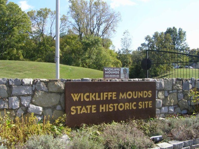
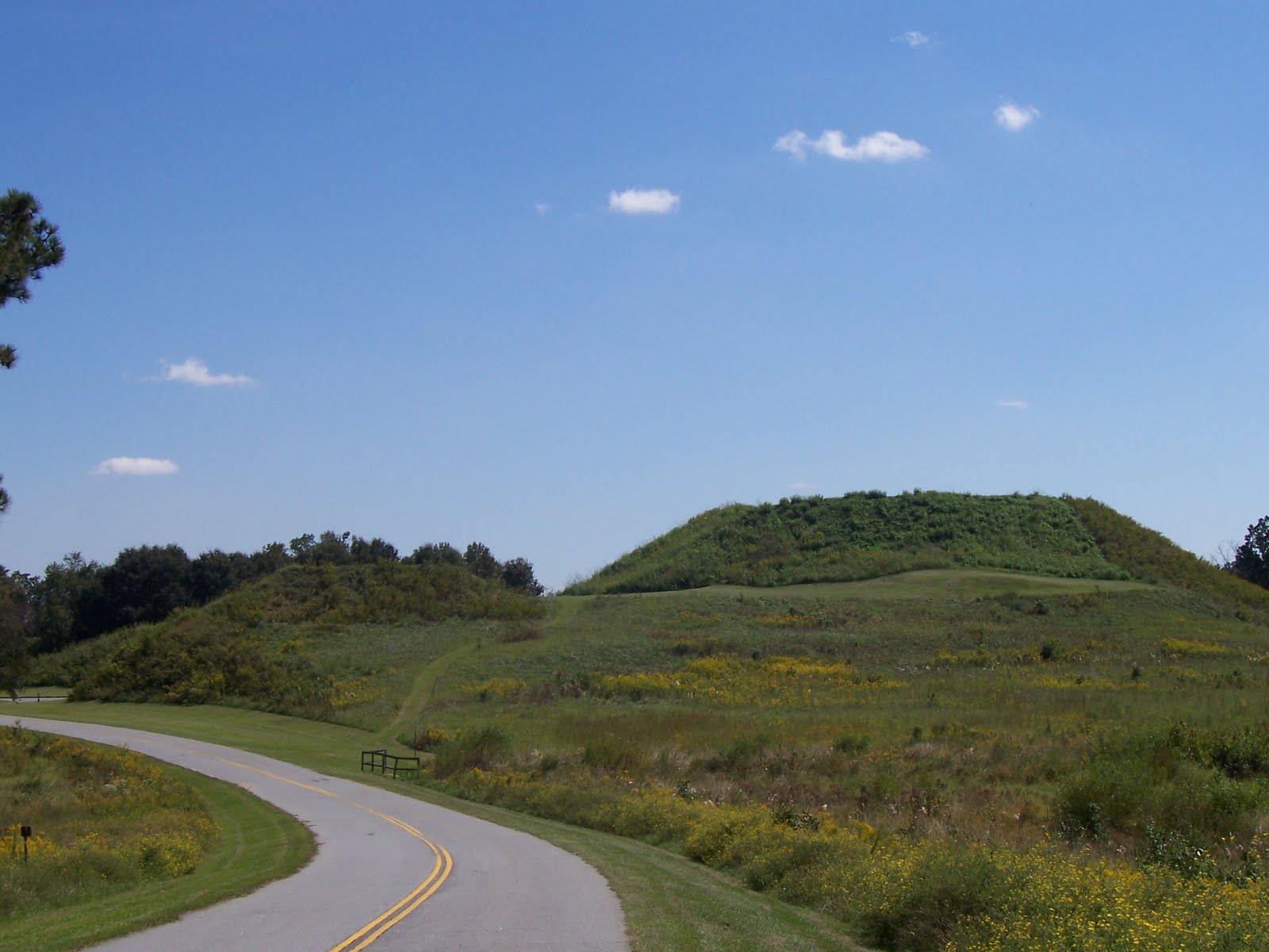
A Native American village once occupied the site of Wickliffe Mounds, about A.D. 1100 to 1350. Here, people of the Mississippian culture built earthen mounds and permanent houses around a central plaza overlooking the Mississippi River. Tour this Native American archaeological site with exhibits from excavations of the 1930’s.
Today, the museum exhibits the excavated features of the mounds with displays of Mississippian pottery, stone tools, artifacts showcasing their way of life and artwork, and the architecture of mounds and houses. Visitors have a spectacular view of the bluff area on top of the Ceremonial Mound, the largest mound on the site.
Scientific archaeological research through Murray State University has revealed important information about the Mississippian people here. This registered archaeological site (15BA4) is on the National Register of Historic Places, a Kentucky Archaeological Landmark.